
EXPLORATION HISTORY
Sri Lanka occupies a strategically important position within the Indian Ocean and possesses substantial offshore sedimentary basins that remain significantly underexplored when compared with neighbouring petroleum provinces.
EXPLORATION HISTORY OF THE MANNAR BASIN
The very first discovery of petroleum in Sri Lanka was at the Pesalai-1 well drilled by Soviets in 1974, fifteen km north of the Mannar Basin.
Formation water recovered from a Lower Cretaceous sandstone in the well contained dissolved gas with heavy ends through pentane.
In 1976 Pexamina Pacific collected seismic data in the northern part of the basin and in 1981 Cities Service acquired more seismic data in the same area.
In the same year Cities group drilled Pearl-1 on the northeast shelf and the well-established the presence of thick Upper Cretaceous sandstones in the Mannar Basin.
In September 1981 Phoenix Canada Oil Company Limited signed a Production Sharing Agreement with Ceylon Petroleum Corporation (CPC) on acreage in the southern part of the Mannar Basin. Under a tripartite agreement between CPC, Phoenix and Petro-Canada International Assistance Corporation, Petro-Canada acquired 980 km of seismic data in the same area.
In 2001 petroleum exploration in the Mannar Basin resumed with TGS-NOPEC acquiring 1200 km of seismic data. A detailed interpretation report carried out by New South Global Ltd. highlighted significant hydrocarbon potential in the Mannar Basin which prompted TGS-NOPEC to acquire additional 4500 km of seismic data in the basin in 2005.
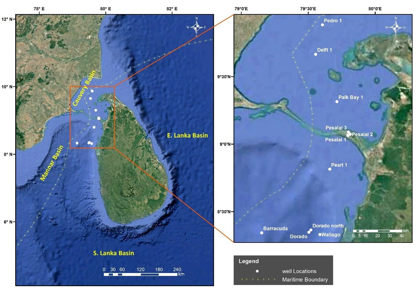
Well locations map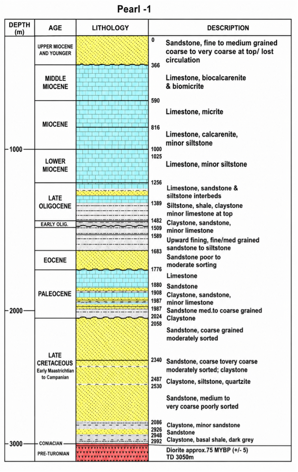
Generalized lithostratigraphic section of the Pearl-1 well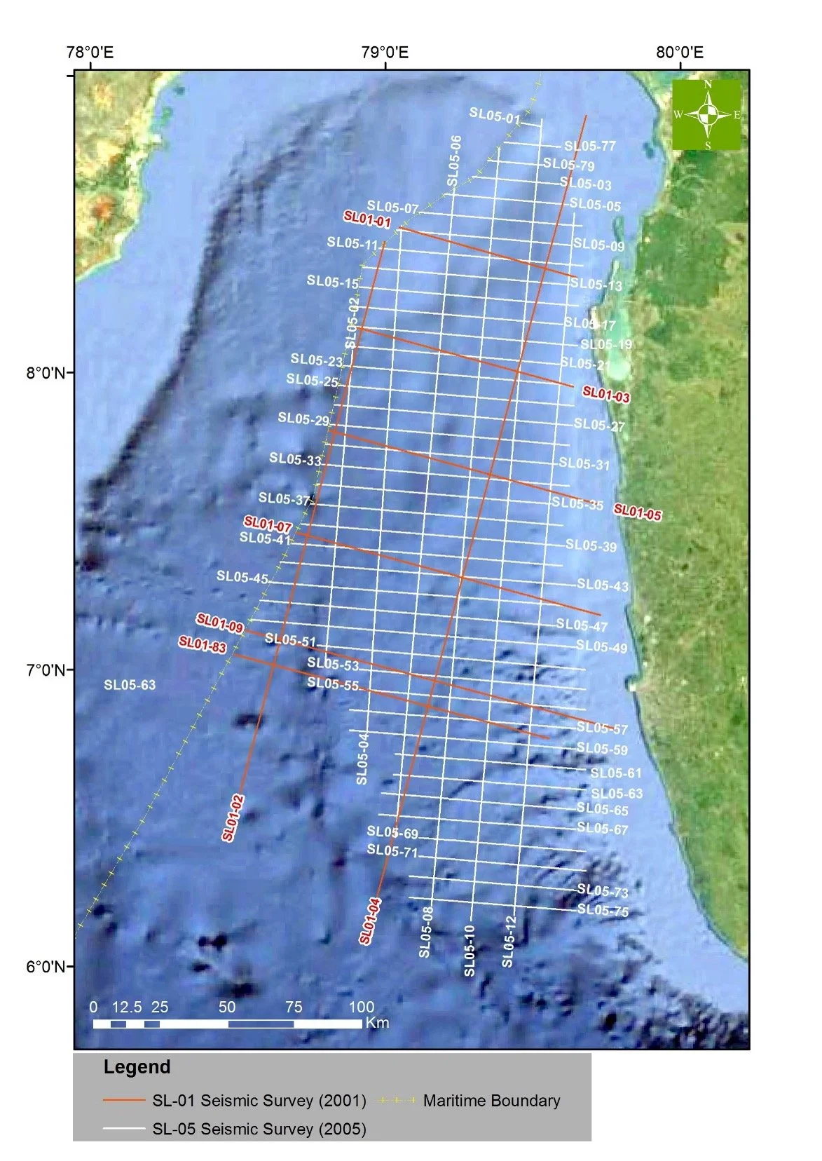
A map of 2D seismic surveys (SL 01 & SL 05)In September 2007, the Government of Sri Lanka (GOSL)launched a licensing round in the Mannar Basin which resulted in signing a Petroleum Resources Agreement between GOSL and Cairn Lanka (Pvt.) Limited in 2008. The Cairn exploration block SL2007-01-001 covering 3000 km2 was in the northern part of the Mannar Basin in water depths between 500 and 1800 m. In 2009 Cairn acquired 1800 sq. km of 3D seismic data in the block and proceeded to drill three exploratory wells, Dorado 91H/1Z, Barracuda 1G/1 and Dorado North 82K/1 in 2011.
The first two wells, Dorado and Barracuda, encountered gas and condensate in Upper Cretaceous sandstones. These wells also established the presence of good quality reservoir rocks, mature source rocks and adequate seal rocks proving the presence of a working petroleum system capable of hosting significant hydrocarbon accumulations in the basin. Encouraged by the discoveries Cairn accumulated further 600 km2 of 3D seismic data in the block. The third and the fourth wells by Cairn, Dorado North and Wallago were found to contain reservoir rocks but they were water-bearing. The fourth well did not reach the target depth due to problems with the drilling vessel. Later Cairn was acquired by Vedanta Resources Limited and the exploration block was relinquished in 2016.
Meanwhile Schlumberger-Western Geco have conducted work focusing on the Mannar Basin, including reprocessing existing data, and acquiring new data in 2018. In 2026 Schlumberger -Western Geco FZE produced a high -resolution pseudo-3D volume, the ExploreCube, using available 2D seismic data in the Mannar Basin. As per Schlumberger the 3D volume facilitates clearer interpretation of geological features and a better understanding of structural and stratigraphic complexities in the basin.
A map of available multiclient seismic data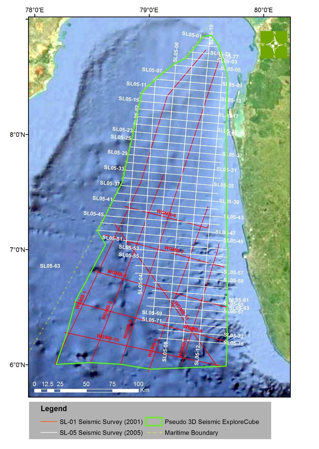
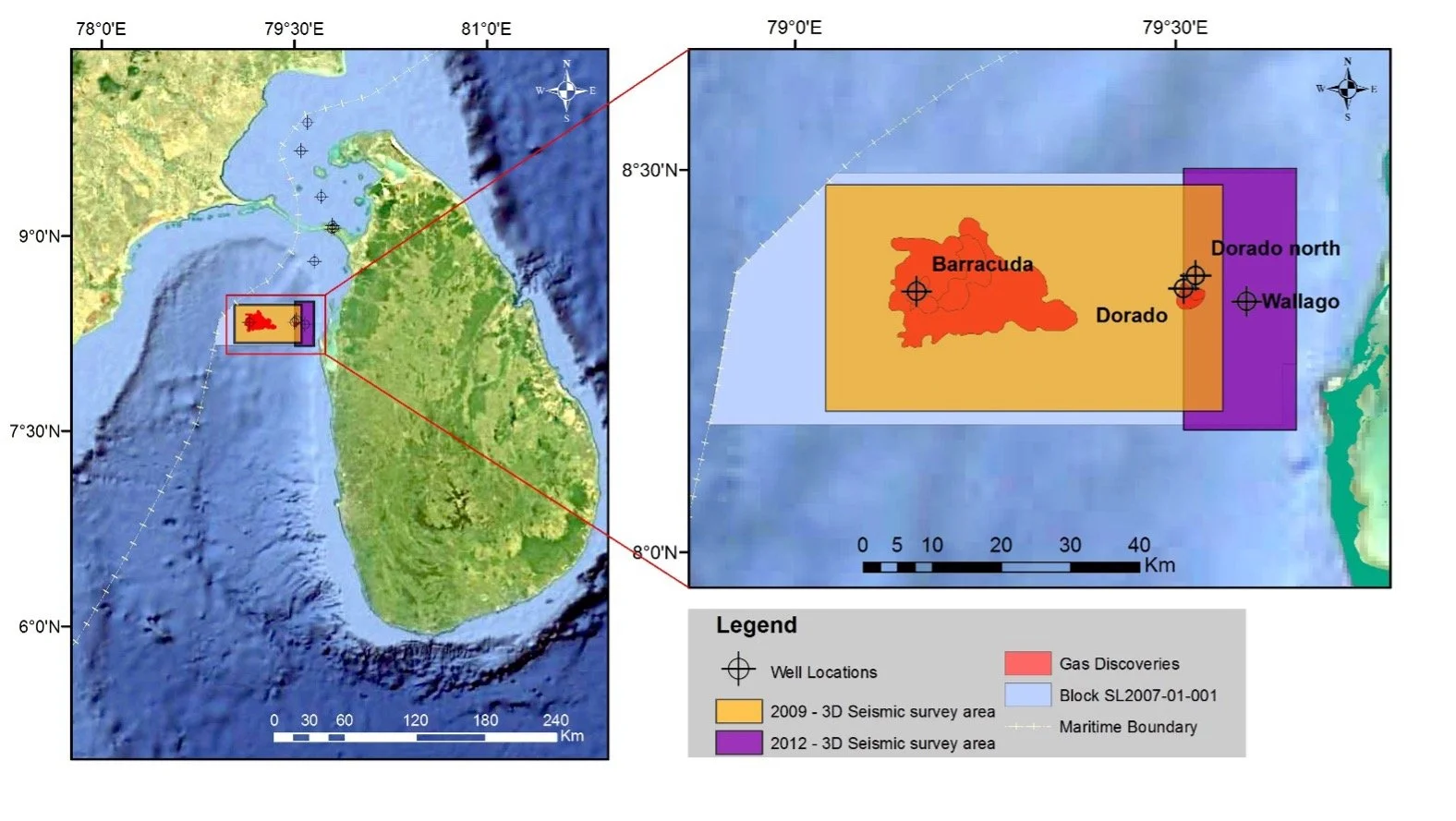
Map of Cairn exploration block SL2007-01-00. Drilled well locations, Gas discoveries and 3D seismic surveysHYDROCARBON POTENTIAL OF THE MANNAR BASIN
Introduction
The Mannar Basin is located southeast of India and west of Sri Lanka (Figure 1). The majority of the basin lies in water depths exceeding 1000 m increasing to 3000m in the south. The India-Sri Lanka maritime boundary divides the basin nearly in half and the Sri Lanka side of the basin covers approximately 42000 km2. Geologically it is an intra-cratonic failed rift separating the two countries.
The very first discovery of petroleum in Sri Lanka was at the Pesalai-1 well drilled by Soviets in 1974, fifteen km north of the Mannar Basin. Formation water recovered from a Lower Cretaceous sandstone in the well contained dissolved gas with heavy ends through pentane. In 1976 Pexamina Pacific collected seismic data in the northern part of the basin and in 1981 Cities Service acquired more seismic data in the same area. In the same year Cities group drilled Pearl-1 on the northeast shelf and the well-established the presence of thick Upper Cretaceous sandstones in the Mannar Basin.
In September 1981 Phoenix Canada Oil Company Limited signed a Production Sharing Agreement with Ceylon Petroleum Corporation (CPC) on acreage in the southern part of the Mannar Basin. Under a tripartite agreement between CPC, Phoenix and Petro-Canada International Assistance Corporation, Petro-Canada acquired 980 km of seismic data in the same area.
In 2001 petroleum exploration in the Mannar Basin resumed with TGS-NOPEC acquiring 1200 km of seismic data. A detailed interpretation report carried out by New South Global Ltd. highlighted significant hydrocarbon potential in the Mannar Basin which prompted TGS-NOPEC to acquire additional 4500 km of seismic data in the basin in 2005.
In September 2007, the Government of Sri Lanka (GOSL)launched a licensing round in the Mannar Basin which resulted in signing a Petroleum Resources Agreement between GOSL and Cairn Lanka (Pvt.) Limited in 2008. The Cairn exploration block SL2007-01-001 covering 3000 km2 was in the northern part of the Mannar Basin in water depths between 500 and 1800 m. In 2009 Cairn acquired 1800 sq. km of 3D seismic data in the block and proceeded to drill three exploratory wells, Dorado 91H/1Z, Barracuda 1G/1 and Dorado North 82K/1 in 2011. The first two wells, Dorado and Barracuda, encountered gas and condensate in Upper Cretaceous sandstones.
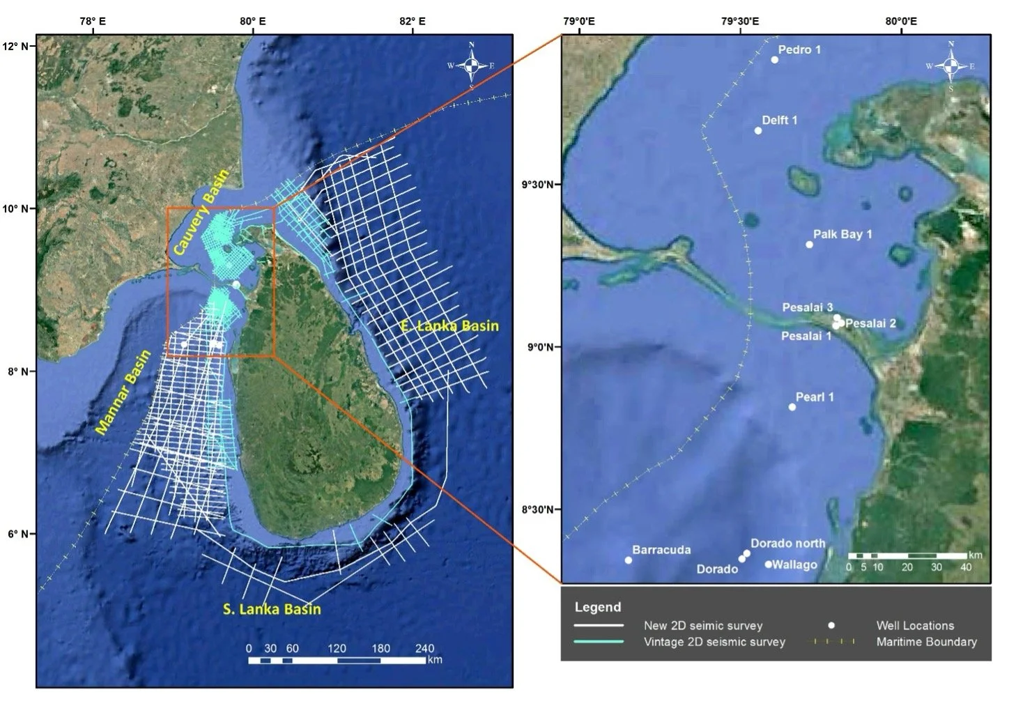
Figure 01. Sedimentary basins locations, 2D seismic data coverage and the well-locations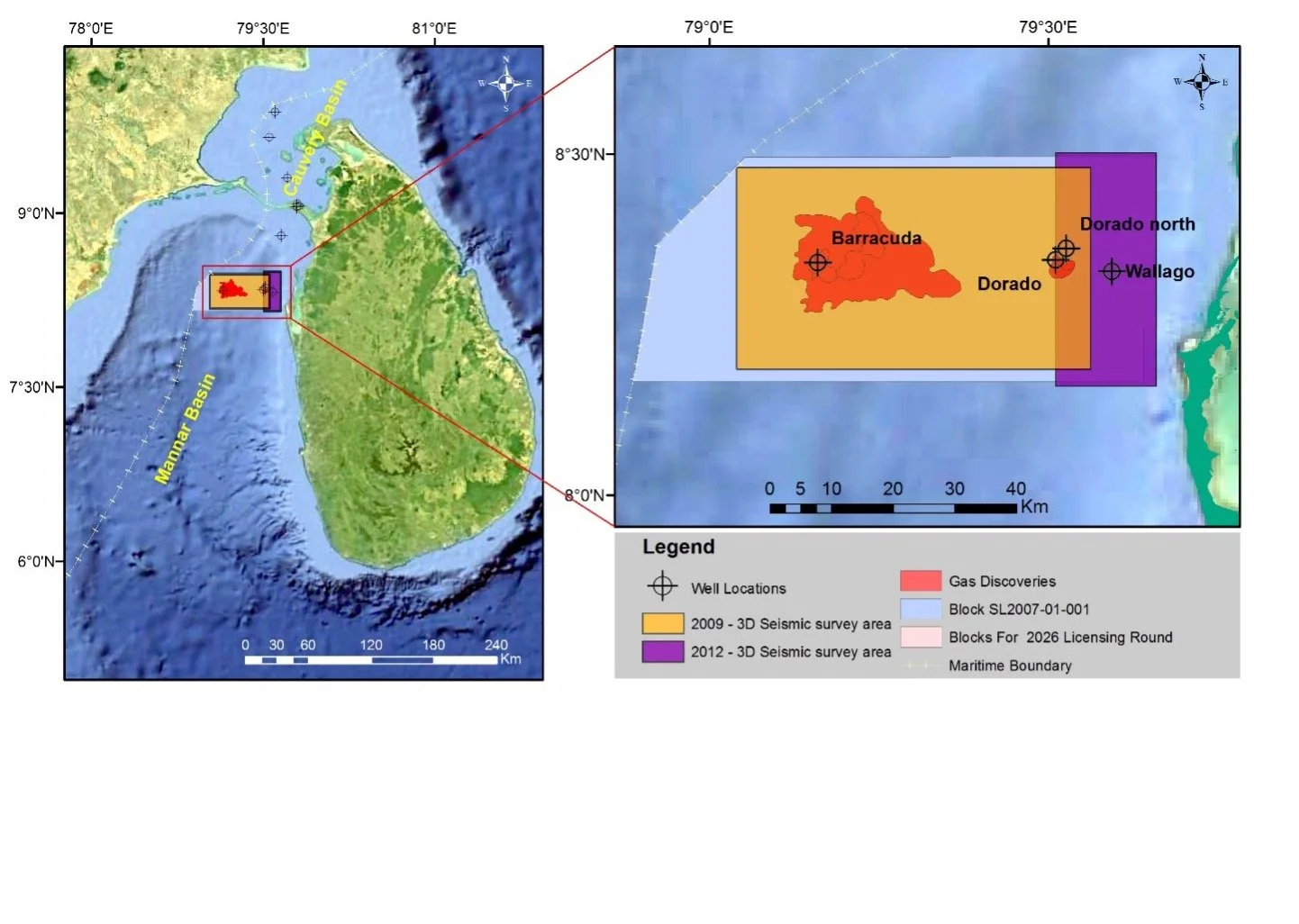
Figure 02. A map showing the block SL2007-01-001, 3D Seismic data coverage, Well locations and Gas discoveriesTectonostratigraphic Evolution
The tectonostratigraphic evolution of the Mannar Basin can be divided to a synrift period and a postrift or sag period. The earliest sediments within the synrift sequence, associated with the breakup of Gondwana, are believed to consists of Jurassic sediments that are preserved onshore in Sri Lanka and India. Jurassic rocks preserved in north-south trending grabens onshore Sri Lanka consist of arkosic sandstones and black carbonaceous shales. These rocks have yielded a variety of plant fossils and rare vertebrate fossils. Although not penetrated in any of the offshore wells (most are shallow and drilled on basement highs) it has been interpreted that bright amplitude packages present just above the basement in seismic data may represent Jurassic strata.
The development of the Mannar Basin related to the breakup of Gondwana started with the separation of Africa from India. The Mannar Basin is believed to have been initiated at this time by counter-clockwise rotation of Sri Lanka away from India. The basin continued to develop as India and Sri Lanka separated from Australia and Antarctica. The breakup is timed by the magnetic anomaly M11dated at 134 million years. The Mannar Basin is believed to have undergone strike-slip movement, more counter-clockwise movement and widening prior to the breakup.
The postrift stage of the Mannar Basin dates from Early Cretaceous times (134 million years) during which the basin underwent thermal sagging (Figure 3). Late Cretaceous and Early Tertiary basalt flows and intrusions contemporaneous with Deccan flood basalt in India that originated from the Reunion hotspot are present in the basin. Seismic data show an Eocene inversion in the basin which is probably related to the Himalayan Orogeny.
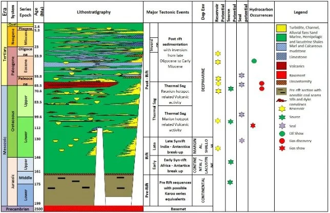
Figure 03. A generalized stratigraphic column of the Mannar BasinPetroleum System
The presence of a viable petroleum system in the basin was proven by the two gas discoveries Dorado and Barracuda in the northern part of the basin. The drilling results and studies to date have indicted the presence of source rocks, reservoir rocks, and stratigraphic and structural traps and migration pathways for hydrocarbons expelled from mature source rocks in the basin.
Source rocks
As per the geochemical results of drill cuttings from Dorado, Dorado North, Barracuda and Wallago exploration wells and according to available literature the strata appears to have the best potential for source rocks in the basin.
Continental to lacustrine depositional environment has been envisaged in the Late Jurassic with Type III source rocks. Carbonaceous shales in these have been found to contain TOC of 3 to 5%. Carbonaceous shale intervals analogous to those observed onshore are likely to be present within the Mannar Basin. Basin modelling results suggest that these source rocks would have entered the oil window approximately 100–130 million years ago and subsequently the gas window around 70–110 million years ago.
The Pesalai 1 well drilled some 15 km north of the Mannar Basin penetrated an approximately 300 m thick Albian source rock interval with 6% TOC and HI of 350 mg HC/g TOC. These have been interpreted as marine shales with Type II kerogen. Basin modelling studies shows that the Albian source rocks reside within the dry gas window at the basin depocentre and are interpreted to have entered the oil window approximately 80 million years ago and the gas window around 100 million years ago in the deeper part of the Mannar Basin.
The Dorado, Dorado North and Barracuda wells all penetrated Campanian-Masstrichtian age, Type II and Type III source rocks with TOC ranging from 1 to 3%. According to basin modelling studies these source rocks have entered the oil window around 45 million years ago at the central part of the basin but are immature in the basin margin area.
Reservoir Rocks and traps
The oldest reservoir rocks in the area, interpreted to be Lower Cretaceous, were drilled in the Delft-1 well drilled in the Cauvery Basin which borders the Mannar Basin to the north. The well has penetrated a massive boulder conglomerate and thin sands associated with dark shale and coal below a major unconformity at 1433 m. The sands have been described as moderately coarse grained with fair to good porosities. Well-developed channels could be seen in seismic section at this interval. It is conceivable that the Mannar Bain with a thicker column of sedimentary rocks would have Lower Cretaceous sandstone reservoir rocks. The play types at this interval could include fault bounded closures and pinch outs with limestone and shale beds providing top seal.
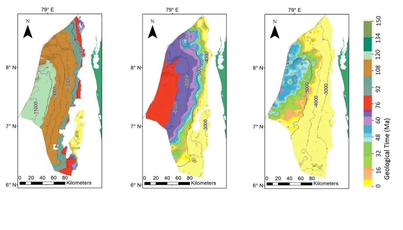
Figure 05. Maturity maps of (a) Late Jurassic, (b) Albian and (c) Campanian-Maastrichtian source rock levels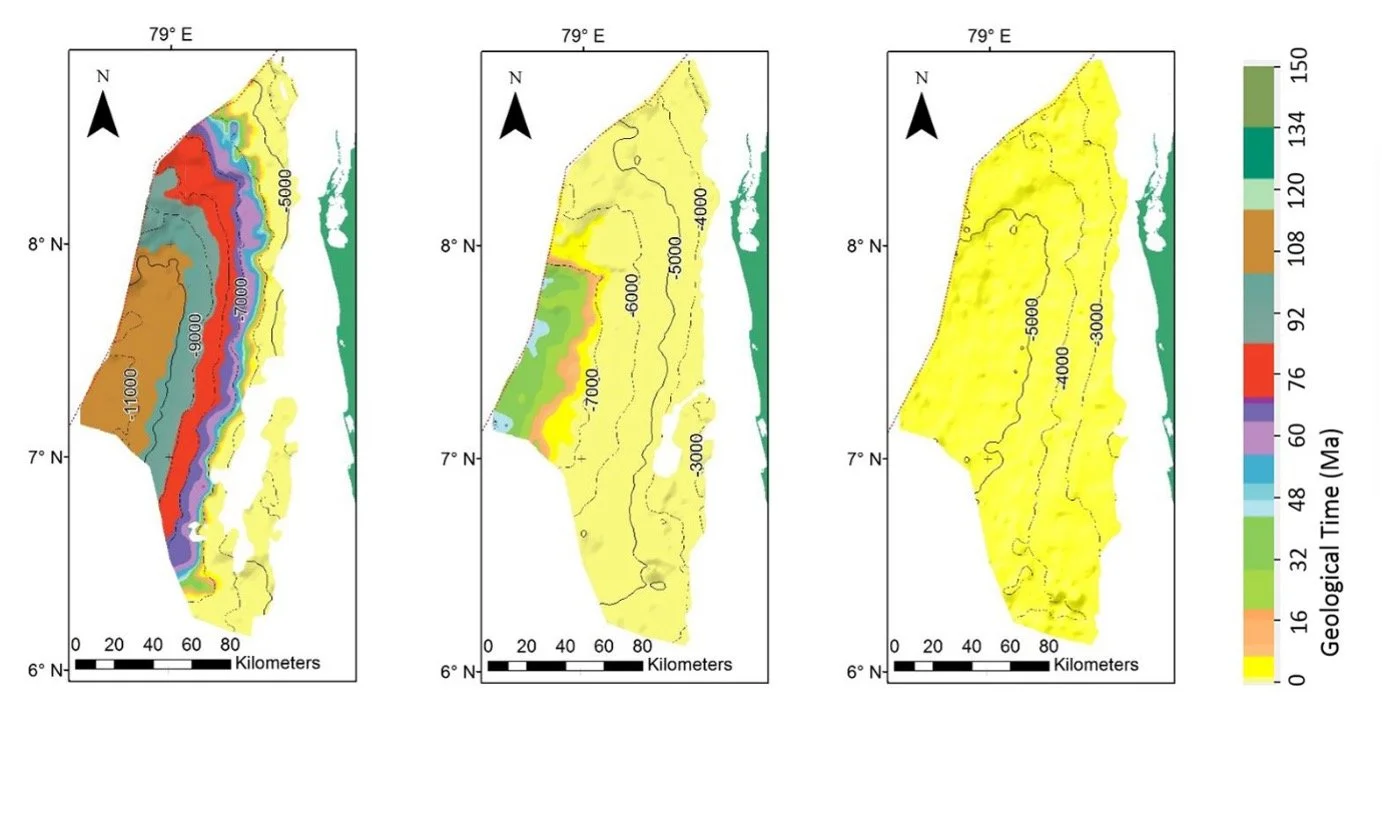
Entrance into the Oil window (a) Late Jurassic, (b) Albian and (c) Campanian-Maastrichtian source rock levels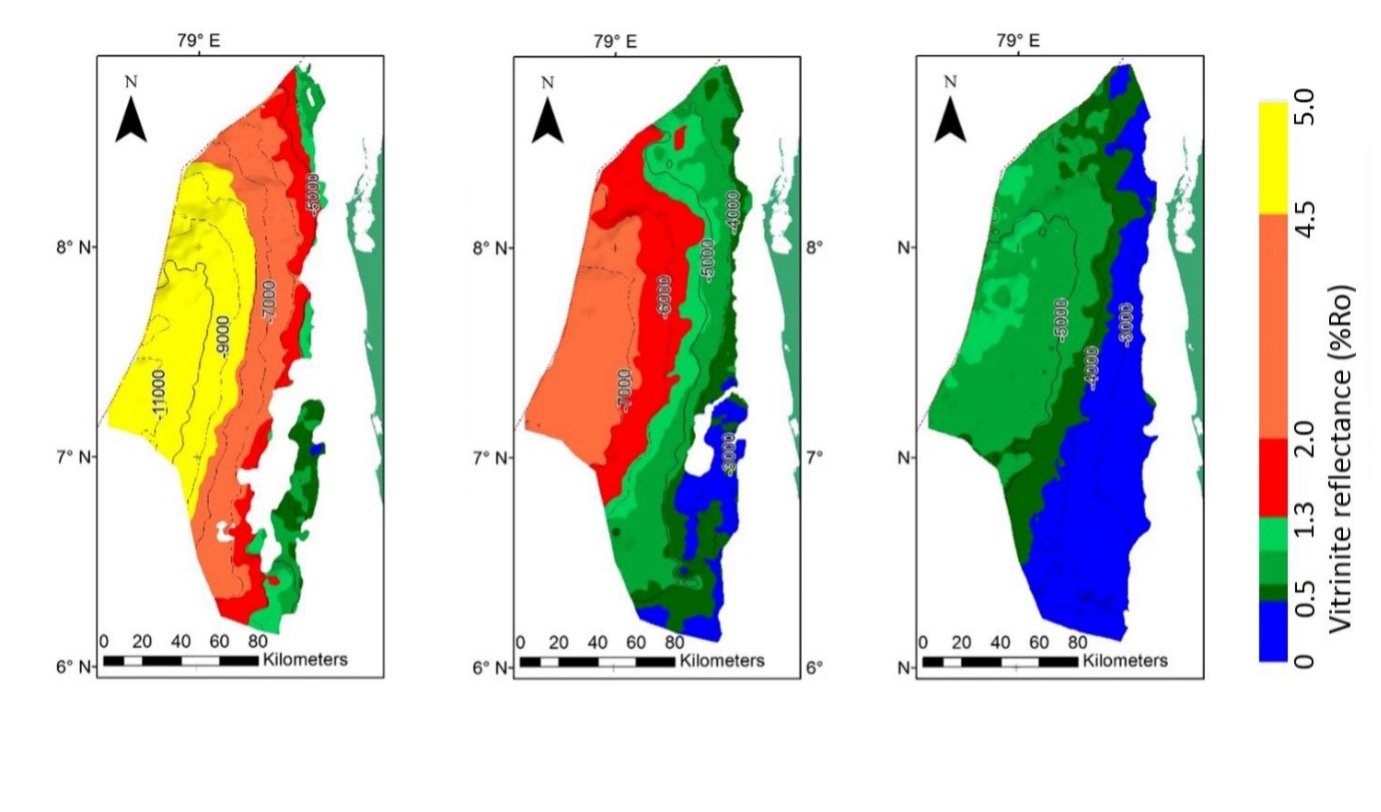
Entrance into the Gas window (a) Late Jurassic, (b) Albian and (c) Campanian-Maastrichtian source rock levelsThe primary reservoir rocks in the Upper Cretaceous include submarine fans, channels and other sand-rich deposits associated with deep water channel systems. Sandstone intervals with good reservoir properties were encountered in all the wells drilled in the northern part of the Mannar basin. They were interpreted to be deposited by gravity flows into a deep-water open marine setting and the seismic data in the basin show well developed submarine channel systems. Trapping mechanisms include updip pinchouts and structural closures including force fold structure due to intrusives.
The Lower Tertiary interval contain a well-developed submarine fan system with distinct lobes and major channels, particularly in the southern part of the basin. The convex nature of the mounds indicating less compaction compared to the surrounding clayey sediments suggests a sand—rich submarine fan system akin to those in the Starbroek block offshore Guyana.
Hydrocarbon generation and migration
Maturation studies including burial history and thermal modelling have been carried out using temperature and vitrinite reflectance data form the Cairn wells. The results indicate that the Early Cretaceous and older source rocks may be in the wet/dry gas window where as the Late Cretaceous source rocks have reached the oil to gas window.
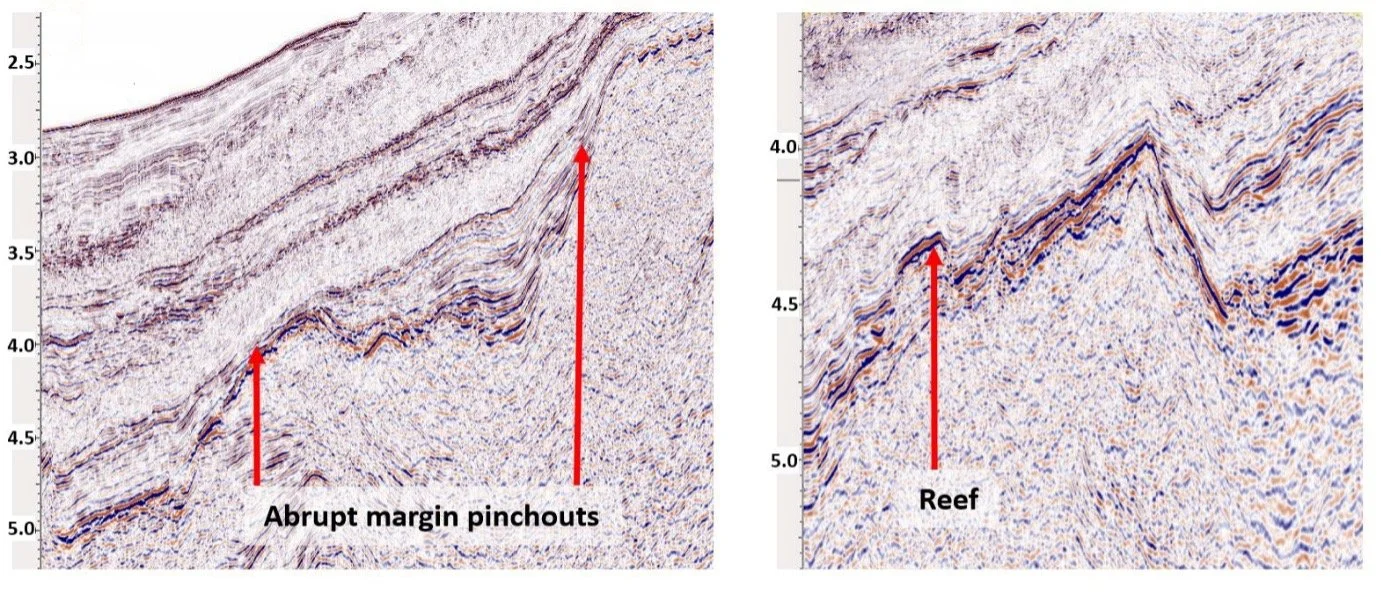
Lower Cretaceous plays and leads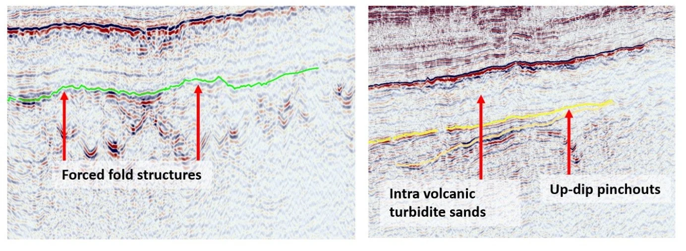
Upper Cretaceous plays and leads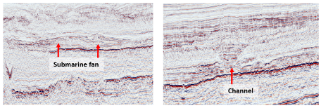
Tertiary Cretaceous plays and leadsREGISTER YOUR INTEREST
Register your organisation's interest in the Sri Lanka Licensing Round 2026 and receive further information on participation opportunities.