
SRI LANKA THE NEW EXPLORATION FRONTIER IN 2026
Sri Lanka occupies a strategically important position within the Indian Ocean and possesses substantial offshore sedimentary basins that remain significantly underexplored when compared with neighbouring petroleum provinces.

WHY SRI LANKA?
The Mannar Basin is an offshore sedimentary basin located off Sri Lanka’s west coast, extending into deep and ultra-deep water. It forms part of the broader Cauvery Basin system and has demonstrated a working petroleum system with confirmed gas discoveries.
This licensing round offers access to high-potential offshore acreage in a basin that combines geological prospectivity with strong commercial fundamentals and a clear domestic gas market.
PROVEN PETROLEUM SYSTEM
Exploration to date has confirmed mature source rocks, effective migration, high-quality reservoirs, regional seals and working traps.
SIGNIFICANT REMAINING UPSIDE
Large parts of the basin remain lightly explored, with modern seismic revealing multiple undrilled structures and stratigraphic opportunities.
STRONG DOMESTIC MARKET
Sri Lanka’s power and industrial sectors create long-term demand for natural gas, supporting project economics.
STABLE AND
TRANSPARENT FRAMEWORK
Sri Lanka offers a clear regulatory framework, contractual certainty and a transparent licensing process.
ENERGY TRANSITION ALIGNMENT
Gas from Mannar supports coal displacement, renewable integration and lower-emission energy supply.
INTERNATIONAL MARKET POTENTIAL
Sri Lanka presents significant potential for international investment, supported by a strategic location, competitive opportunities and access to growing regional markets.
BASIN OVERVIEW
Rift/passive margin basin
Linked to Gondwana breakup
Geological continuation of the Cauvery system
PETROLEUM SYSTEM ELEMENTS
Source: Mature shales
Reservoir: Clastics and carbonates
Seals: Shales and evaporites
Traps: Structural and stratigraphic
EXPLORATION STATUS
Confirmed gas discoveries
Proven petroleum system
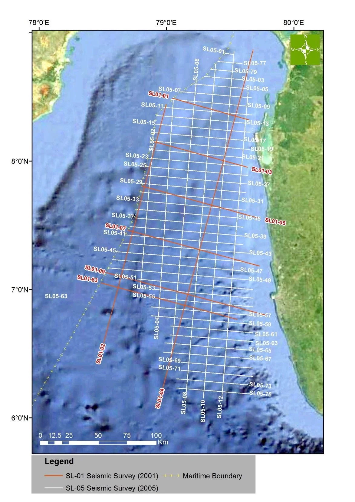
Regional 2D seismic coverage with targeted 3D
Multiple undrilled leads and prospects
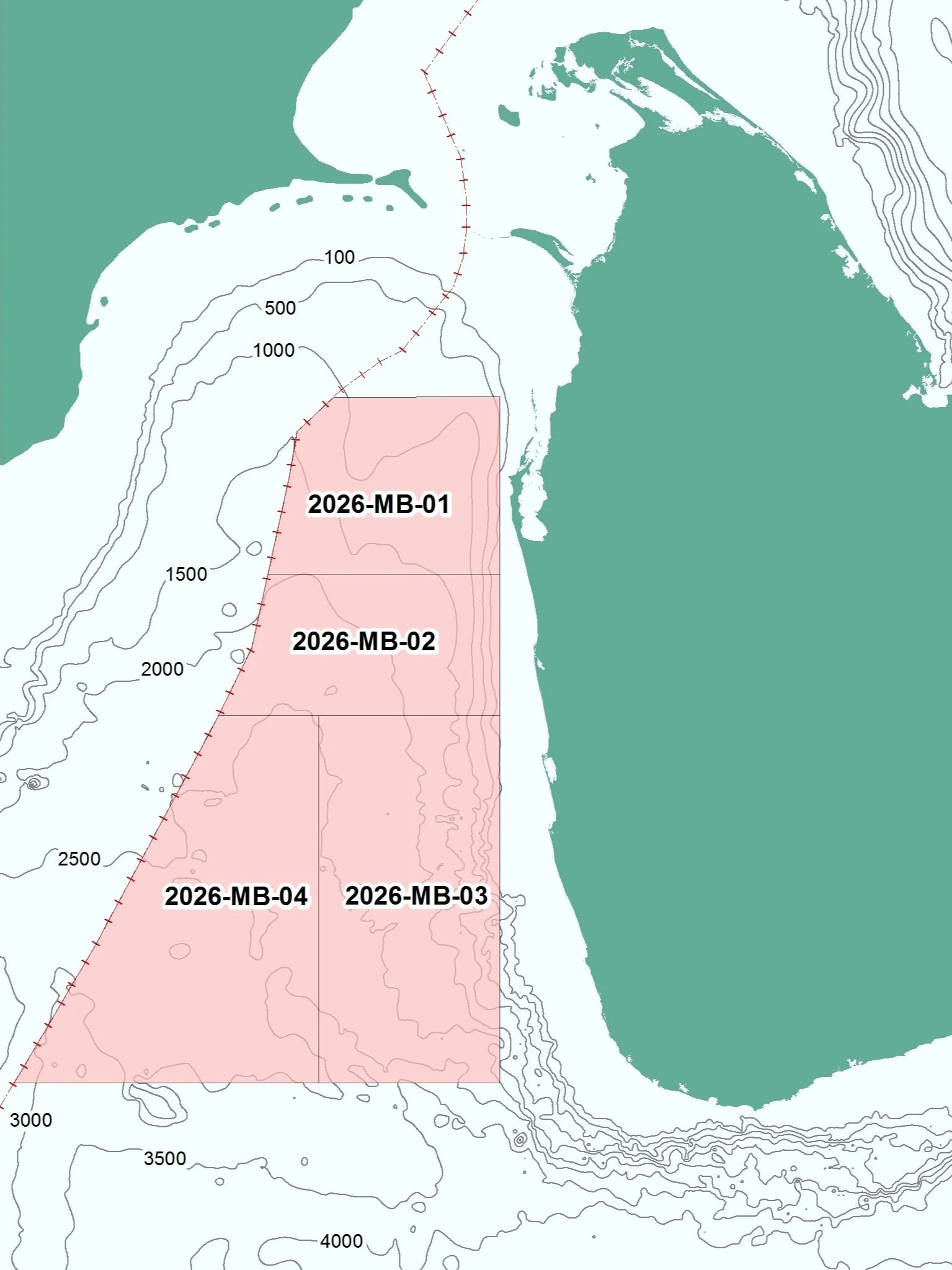
BLOCKS ON OFFER
Water Depth (approx)
Block ID
Block Area km²
2026-MB-01
2026-MB-02
5948.95 km²
5689.05 km²
100m to 2000m
100m to 2500m
2026-MB-03
10597.67 km²
100m to 3000m
2026-MB-04
11728.30 km²
100m to 3000m

EXPLORATION HISTORY OF THE MANNAR BASIN
The Mannar Basin is Sri Lanka's most prospective offshore basin and has been the focus of exploration for more than five decades. Geological studies, seismic surveys and the drilling of the Dorado and Barracuda wells confirmed a working petroleum system, with Sri Lanka's first offshore natural gas discoveries made in 2011. Continued investment in subsurface data has further strengthened the basin's exploration potential.
REGISTER YOUR INTEREST
Register your organisation's interest in the Sri Lanka Licensing Round 2026 and receive further information on participation opportunities.